
Page 27 - 2024F
P. 27
20 UEC Int’l Mini-Conference No.53
especially for static visualizations where compu- types: restaurants, retail stores (including con-
tation time is less critical, DE provides a better venience stores and supermarkets), and parking
result. lots.
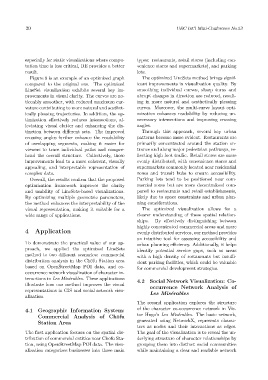
Figure 8 is an example of an optimized graph The optimized LineSets method brings signif-
compared to the original one. The optimized icant improvements in visualization quality. By
LineSet visualization exhibits several key im- smoothing individual curves, sharp turns and
provements in visual clarity. The curves are no- abrupt changes in direction are reduced, result-
ticeably smoother, with reduced maximum cur- ing in more natural and aesthetically pleasing
vature contributing to more natural and aesthet- curves. Moreover, the multi-curve layout opti-
ically pleasing trajectories. In addition, the op- mization enhances readability by reducing un-
timization effectively reduces intersections, al- necessary intersections and improving crossing
leviating visual clutter and enhancing the dis- angles.
tinction between different sets. The improved Through this approach, several key urban
crossing angles further enhance the readability patterns become more evident. Restaurants are
of overlapping segments, making it easier for primarily concentrated around the station en-
viewers to trace individual paths and compre- trance and along major pedestrian pathways, re-
hend the overall structure. Collectively, these flecting high foot traffic. Retail stores are more
improvements lead to a more coherent, visually evenly distributed, with convenience stores and
appealing, and interpretable representation of supermarkets commonly located near residential
complex data. zones and transit hubs to ensure accessibility.
Overall, the results confirm that the proposed Parking lots tend to be positioned near com-
optimization framework improves the clarity mercial zones but are more decentralized com-
and usability of LineSets-based visualizations. pared to restaurants and retail establishments,
By optimizing multiple geometric parameters, likely due to space constraints and urban plan-
the method enhances the interpretability of the ning considerations.
visual representation, making it suitable for a The optimized visualization allows for a
wide range of applications. clearer understanding of these spatial relation-
ships. By effectively distinguishing between
highly concentrated commercial areas and more
4 Application evenly distributed services, our method provides
an intuitive tool for assessing accessibility and
To demonstrate the practical value of our ap- urban planning efficiency. Additionally, it helps
proach, we applied the optimized LineSets identify potential service gaps, such as areas
method to two different scenarios: commercial with a high density of restaurants but insuffi-
distribution analysis in the Chōfu Station area cient parking facilities, which could be valuable
based on OpenStreetMap POI data, and co- for commercial development strategies.
occurrence network visualization of character in-
teractions in Les Misérables. These applications 4.2 Social Network Visualization: Co-
illustrate how our method improves the visual occurrence Network Analysis of
representations in GIS and social network visu-
alization. Les Misérables
The second application explores the structure
4.1 Geographic Information System: of the character co-occurrence network in Vic-
Commercial Analysis of Chōfu tor Hugo’s Les Misérables. The basic network,
Station Area generated using NetworkX, represents charac-
ters as nodes and their interactions as edges.
The first application focuses on the spatial dis- The goal of the visualization is to reveal the un-
tribution of commercial entities near Chōfu Sta- derlying structure of character relationships by
tion, using OpenStreetMap POI data. The visu- grouping them into distinct social communities
alization categorizes businesses into three main while maintaining a clear and readable network